

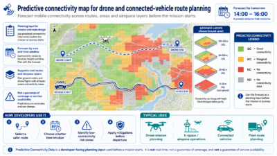
 The API supports both aerial and terrestrial planning scenarios. Developers can specify a polygonal area, a future start and end time, and the communication service level required by their application. They may also specify the network type, the spatial precision of the response and, where relevant, a height above ground level.
- Drone Flight Planning and BVLOS Mission Preparation: A drone operator or mission-planning application may query the API before a flight to estimate the expected mobile connectivity across a planned operating area and future time interval. By analysing the predicted connectivity at different heights above ground level, the application can identify connectivity-constrained areas or “black volumes” that may affect command-and-control communications or data transmission. This information can be used as an input for route optimisation and operational risk assessment.
- Connected and autonomous Vehicle Route Planning: A mobility platform, fleet-management system or connected-vehicle application may query the API to assess the expected mobile connectivity across a planned route or operating area. The application can identify locations where the required connectivity level might not be met and take this information into account when selecting routes or planning services that depend on mobile-network availability.
- Connectivity-aware Planning for data-intensive Missions: An application may request a connectivity prediction for a service level associated with high-throughput communications, such as video streaming. This can help developers assess whether the expected connectivity conditions are suitable for missions that require continuous transmission of sensor or video data.
Related GSMA Use Cases:
- Safe and efficient Route Planning for autonomous Vehicles: Safe and efficient Route Planning for autonomous vehicles