

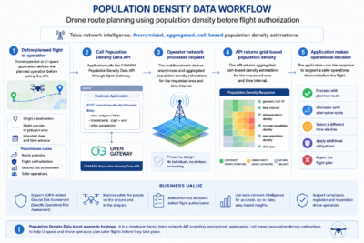
- Drone Ground Risk Assessment and SORA Support: Drone operators and U-space service providers can use the Population Density Data API before a planned flight to estimate the number of people potentially exposed under the flight path. This supports ground risk assessment and helps determine whether the planned operation is acceptable for the intended time window.
- Drone Route and Flight-Time Optimization: Drone applications can compare different routes or time slots and select the option with lower population exposure. This helps operators avoid crowded zones, reduce operational risk and identify safer alternatives before the flight starts.
- Emergency Response Planning: Public authorities and emergency management platforms can use population density estimations to understand where people are likely to be concentrated during a crisis, incident or large-scale disruption. This supports better prioritization of resources, evacuation planning and response coordination.
- Urban Planning and Infrastructure Analysis: City planners can use anonymized population density estimations to understand how areas are used over time, supporting decisions on infrastructure, mobility, public services and urban development.
- Event Management and Crowd Planning: Event organizers and public safety teams can use population density estimations to plan security, access flows, facilities and operational resources around venues and high-attendance areas.
- Data-driven Marketing and Campaign Planning: Marketing teams can use aggregated population density insights to identify high-density areas and optimize the placement, timing and reach of location-based campaigns.
See also at GSMA:
- Drone Flight Planning Risk Assessment: Drone Flight Planning Risk Assessment
- Safe and Efficient Route Planning for autonomous Vehicles: Safe and Efficient Route Planning for autonomous Vehicles.